Locate Ben Rinnes
The grid reference below relates to the trig point on top of Ben Rinnes
Latitude: 57.4023° N
Longitude: 3.2398° W
National Grid Ref: NJ 284354
 Carpark at the start of the path |
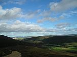
 Looking towards Dufftown |
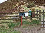
 Information & donations box |
|---|
The Ben is accessed from either the B9009 Dufftown to Glenlivet/ Tomintoul Road or from the Aberlour side the A95 the access road is the unclassified road to Edinvillie.
There is parking in a tarmacced lay-by some 400 yds from the B9009 junction.
The footpath is then accessed via a gateway where you can find information about the Friends and how to join us.
There is also a donations box.
All donations gratefully recieved & will go towards the upkeep of the path.
Thank you for your support
Please be aware that this narrow road is used by some large agricultural vehicles several times a day.
Please park with consideration. Thank you.
Join The Friends of Ben Rinnes, just fill in the Membership application form and send it off to the address on the Contact page
For further info on the activities of The Friends see the Latest News page.


